


In a post a couple days ago (read that post here, Day, the Sixteenth) about the famous Auburn Obelisk, my daughter asked how 18th century surveyors could figure out distances, from town to town for example.
In a world of GPS and satellites, it’s a reasonable question for a seven-year-old and one I had no answer for. And a whole bunch of you asked about it as well. But thanks to my historian friend and knower of all things about New Boston, Dan Rothman, we’ve been able to come up with some possibilities.
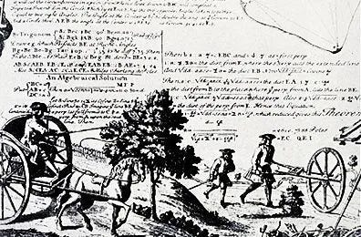
In general, road distances in the 18th century were measured by a "Surveyor's wheel" or an "odometer."
Dan forwarded an amusing story: “I remember my parents using a surveyor’s wheel for some community project in Connecticut forty years ago.
”My father, being a man who always looked for an easier way to do anything, opened the rear hatch of their Subaru wagon and sat facing backwards with his legs dangling, holding the Surveyor's wheel so that its wheel touched the road surface as my mother drove slowly down the road.
“It was a good plan, spoiled only by the fact that my mother was not adept at driving a car with a manual transmission. She popped the clutch and the next time she looked in her rear view mirror my father wasn't there!”
It appears, however, that surveyor’s wheels provided a fair measure of accuracy, but not perfect! Each revolution of the wheel measures a specific distance, such as a yard, meter or half-rod. So, by counting revolutions with a mechanical device attached to the wheel, the surveyor was able to directly measure distance.
On rough terrain, (or pretty much all terrain in 1790) wheel slippage and bouncing could reduce the accuracy. Soft sandy or muddy soil can also affect the rolling of the wheel.
Perhaps Little Bean was right. Maybe we do need to get in our car and see just how accurate the great Auburn Obelisk really is!
Either way, it’s worth mentioning that both Candia and Chester are worthy destinations if you like weird stones.
In Chester, right near town hall, stop and check out the Jacob Chase’s Horse Block, an old horse and carriage stepping stone that dates from the 1750s. Meanwhile, Candia’s Tower Pond offers the hiker an easy saunter to Dog Rock.
You won’t need a surveyor’s wheel for those destinations!
There is one in Bear Brook that has 4 letters. Can’t recall which trail it’s on and can’t recall for sure if it’s A (Auburn) C (Canadian) D (Deerfield) E (Epsom). Can’t find the photo and memory fuzzy but it was impressive.