


Little Bean circles the obelisk.
“Sooo, this is what?” she asks.
The great obelisk of Auburn, N.H. has been confounding travelers for decades, hundreds of years actually. Standing upright about five feet out of the ground as it does at the corner of two old Auburn roads, Dearborn and Raymond to be exact, the pink quartz stone carries the following inscription:
6
MTOCMH
4
MTOCAMH
1790
“Well,” I tell my daughter, “do you know who George Washington was?”
She thinks for a moment. “He was the first president I think?”
“Correct! And that was a long time ago. In fact, George Washington was the president when this stone was carved and put into the ground.”
Back in 1790, travelers between the two towns that sandwiched Auburn (Auburn wasn’t a town back then) needed to know how far they were to Chester or Candia. The great Auburn Obelisk is, in fact, a street sign.
Six Miles To Chester Meeting House
Four Miles To Candia Meeting House
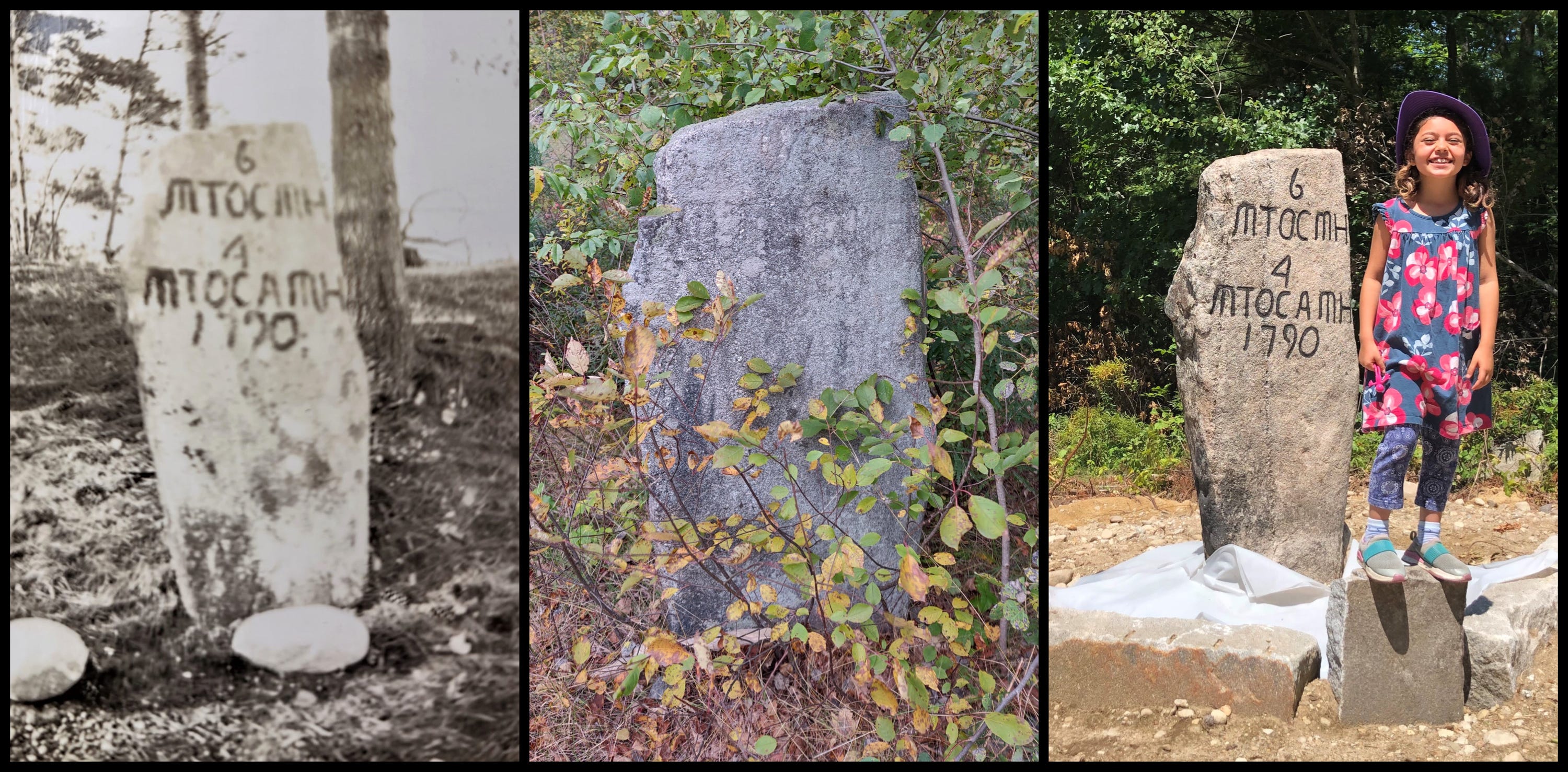
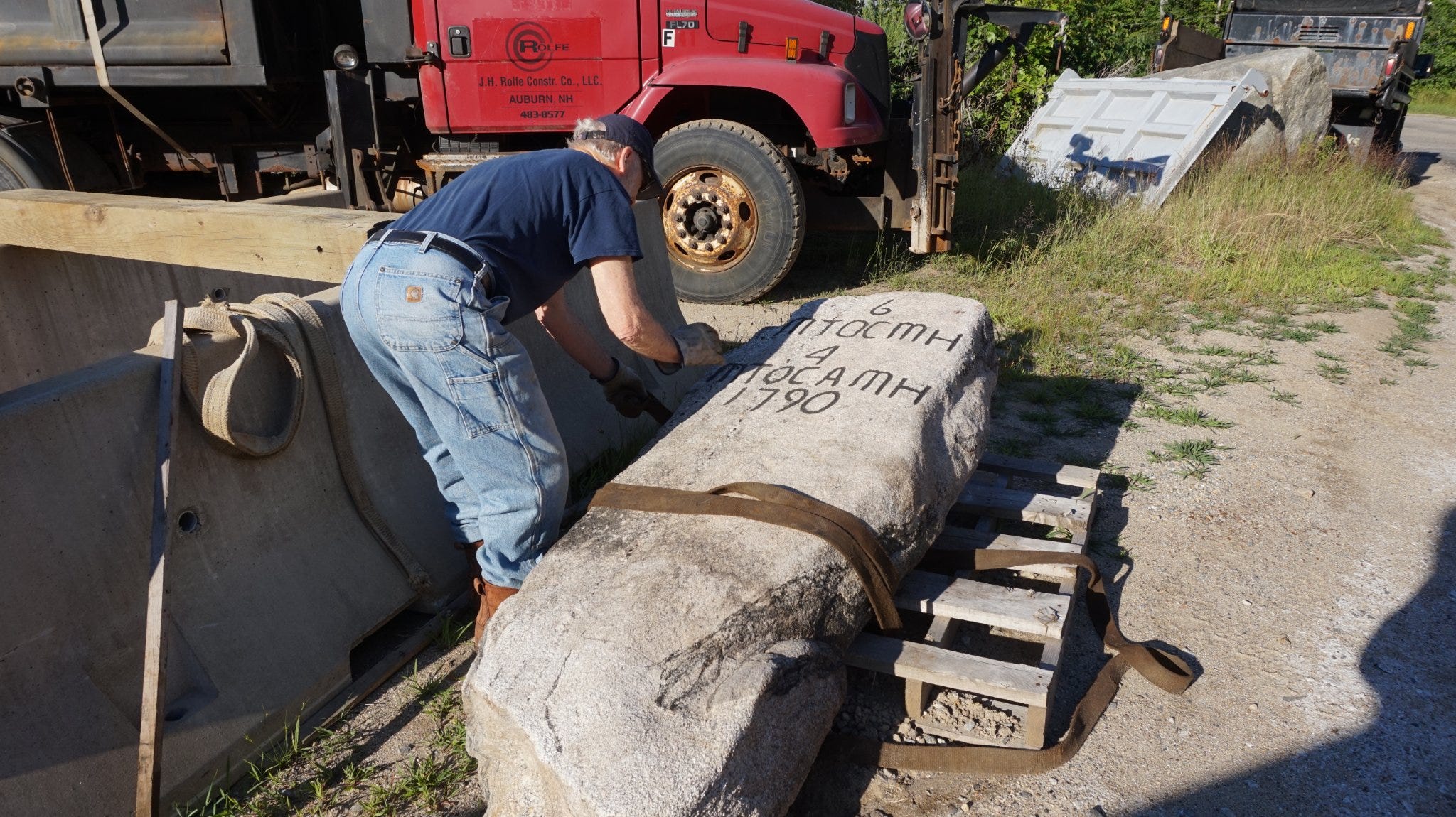
In 1922, the stone was repainted in time for Chester’s Bicentennial. But after that, nothing but neglect and weeds until the Auburn Historical Association stepped in this past spring. Association president Dan Carpenter assembled a team of burly Yankees with big machines and got to work.
The stone was carefully dug out of the ground (perhaps for the first time in its 232-year history) and moved to the Town Shed for cleaning. Dot Carpenter repainted the letters while the boys dug a hole and built a new base.
Finally, the ancient street sign was returned to its corner and there it sits today, complete with a plaque “interpreting” the inscription. Some say there may even be a bench erected at the mini-corner park.
Little Bean runs her fingers over the lettering.
“So, its four miles to one town,” she says pointing north.
“Yup.”
“And it’s six miles to the other,” she says pointing south.
“Yup.”
“How do you know?”
“Uh, what do you mean?”
“Well, like, how did they know?” she asks. “How did they figure that out? Has anyone measured now?”
“I – um, I’m not sure. We could get in the car and drive either way to check and see,” I suggest.
She shrugs. “Nah. They knew what they were doing.”
And so it goes, my baby and me, at a literal crossroads, learning about direction and finding direction. And through it all, the Auburn Obelisk points the way.
The Auburn Obelisk will be featured in our upcoming Field Guide: “NH Rocks That Rock: Memorial Stones.” We’re hoping for a spring time release, but will give all of our Substack subscribers a Cover Reveal at the end of this month. Meantime, our first book in the series is available at my bookstore here: NH ROCKS THAT ROCK.
Be sure to share and subscribe! See you all tomorrow!
I never knew about the obelisk and never would have guessed the meaning. Lived at the other end of town! And how DID they measure a mile?
Loved this! Thank you Dan and Little Bean.