


The Great Mt. Washington Tower
A Very Special Anniversary Is Upon Us

Introduction: This week marks the sixth anniversary of the publication of my book, “The White Mountain: Rediscovering Mount Washington’s Hidden Culture.” We launched the book at Gibson’s Bookstore in Concord and since then, the book has gone into four printings and won several awards, including best NH non-fiction book and a people’s choice award for non-fiction.
It’s fair to say that both writing the book and publishing it has changed my life.
So here today, I thought I’d republish an essay that DIDN’T make it into the book. A lot of material never made it into the book actually. A form of this essay was published in Appalachia Journal and another version was published in my follow-up book “Stories From the White Mountain.” In case you’ve never heard of that book, no worries, no one read it!
Anyway, here’s one of my favorite bits of Mt. Washington non-fiction that has never seen the light of day. In celebration of the book that was so important in my life, I present this new (old) work to you all. Enjoy and thank you for reading!
THE GREAT MOUNT WASHINGTON TOWER
From virtually the moment the Appalachian Mountain Club came into existence in 1876, members were trying to make maps of The White Mountains.
In the first issue of Appalachia in April 1876, AMC Recording Secretary John B. Henck’s first written words are “Being unable to find a reliable map of the White Mountains, I made up my mind to try and make one for myself.”
The essay was titled New Map of the White Mountains and it served as a call to arms to members of the brand-new club to begin work on an accurate and reliable survey of the mountains they loved.
There were other outdoors clubs at the time, most notably The White Mountain Club out of Portland, Maine, but the early AMC was composed nearly to a man of professors, engineers, naturalists and scientists – many from Ivy League Universities. Henck was a graduate of Harvard and the valedictorian of his class of 1840. When he joined the AMC, he was the head of the Department of Engineering at the Massachusetts Institute of Technology.
Most of them understood surveying as a matter of hobby or profession, carrying alidades or theodolites up to summits on their tramping excursions the way hikers today carry trail mix.
At the same time, Dartmouth geography professor and another AMC member, Elihu T. Quimby, had been working for the United States Coastal Survey (which eventually became the United States Geological Survey), using his students and assistants to take readings around the state for the quadrangle maps the government was building.
By 1880, all the elements were in place for what would essentially become the first common trampers guide to the White Mountain Presidential Range. AMC members like founders Sam Scudder and Edward Pickering, along with names we’d all recognize today like Charles Hitchcock and J. Rayner Edmands were gathering data. The government had turned its attention inland. Tourists were staying at the stone hotels at the summit of Mount Washington.
A working, accurate trail and tourist map was the last piece of the puzzle. Only one obstacle remained. The top of New England had become the primary survey position, but Quimby, Edmands and William Pickering, the brother of Edward, needed some method to get above the increasingly crowded summit to take their readings. As unlikely as it seemed given Mount Washington’s open summit, they needed to build a tower.
This would be expensive and difficult work. But Quimby had a plan.
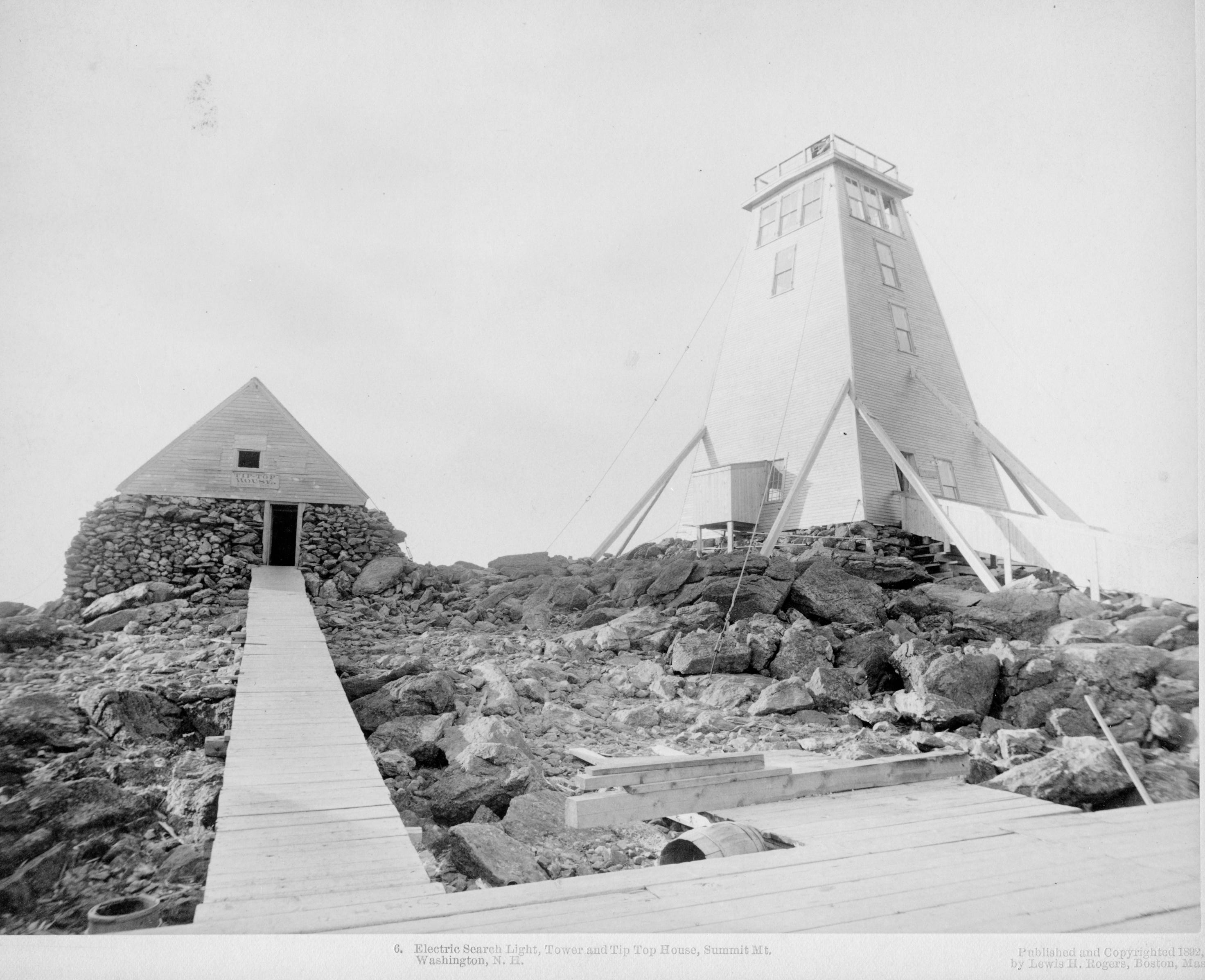
There had already been a tower on Mount Washington. In 1854, developer Tim Easton paid an amazing $500 to erect a wooden framework tower with a hand crank elevator at the summit. He charged tourists 50 cents per person.
“That was a complete failure,” said historian Ron Walter. “People figured they were already high enough and didn’t trust the mechanism. He sold it for scrap two years later for 30 bucks.”
Then, through the 1870s, Quimby had been trying to convince the government to pay to construct a survey tower. He was never successful. In an 1877 issue of Appalachia, Edmands writes that the lack of Congressional appropriation is a “mater of deep regret.”
So, Quimby did what any smart academic seeking funding would do, hat in hand he turned to private organizations, in this case to The Cog Railway. Since 1869, the Cog had been taking tourists to the summit and since 1873, customers had been able to stay in the Cog’s ninety-one room hotel, known as the Summit House.
Quimby’s pitch was simple. The Cog would build it to the specifications of the survey team, Quimby and his team would use it to do the survey work and the Cog could attach it to the hotel and charge tourists to use it.
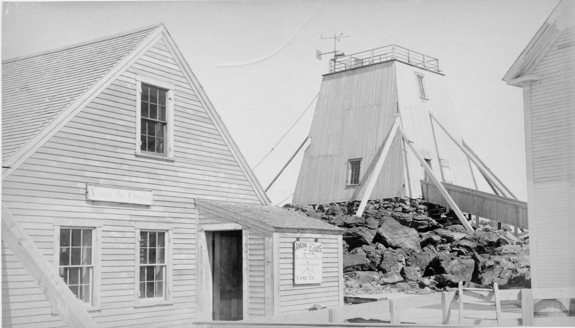
The Cog enthusiastically accepted the terms. In a July 1880 edition of the Mount Washington summit newspaper Among the Clouds, a blurb announced that Professor Quimby would begin work on his tower as soon as the weather was clear. Cog Railway engineer Walter Aiken proudly proclaimed that the tower would be built to stay as a permanent feature.
And so, work on the great Mount Washington Tower finally began.
The primary challenge of building the tower was the same as the challenge of building anything up there today, the weather. More specifically, the wind.
“The instruments couldn’t be affected by the wind,” Walters said. “So, they built a giant log tripod and then encased it in an outside shell.”
It was 27 square feet at the base, tapering to a 14 square foot top. Inside the shell, eight 9-inch spruce timbers reached from the foundation to the top. The structure was them covered in heavy planking and clapboard, but even then, the weather was so severe that moisture was always penetrating the tower.
Still, the tower was finished in the summer of 1880. Tourists began going up for 10 cents a person. And, now that they had perfect sight lines over the tops of all the summit buildings, AMC engineers and scientists began triangulating the White Mountains in earnest.
Once the tower had been built and the data began coming in, building the first hiker map was easy. It only took the AMC and William Pickering one season to publish it. By June 1882, Appalachia issued a copy of the map and Pickering published an accompanying field guide called “Walking Guide to the Mt. Washington Range.” Suddenly, trampers had a reliable map, and the doors to hiking in the White had been flung wide open.
Pickering’s original map had wide contours of 500-foot intervals. The entire state of New Hampshire was divided into 26 regions, with letters and numbers used to further designate landmarks or peaks. Mount Washington, for example, is listed as F6.1, the highest peak in area 6 of New Hampshire region F.
The scales were given in kilometers as well as miles and early AMC publications often used the metric system, more evidence of the early founders being scientists.
By the early 1890s, William and his founder brother Edward had moved on, turning their focus to astronomy. William discovered the Saturn satellite Phoebe in 1899 and predicted the existence of Pluto. Finally, in 1911, the great map maker moved to Jamaica, spending the final years of his life at his Woodlawn Observatory in Mandeville. But his original White Mountain map was used as the basis for AMC maps extending well into the 20th century.
But what of the original tower? As it turns out, the Mount Washington tower had one more illuminating chapter to its life.
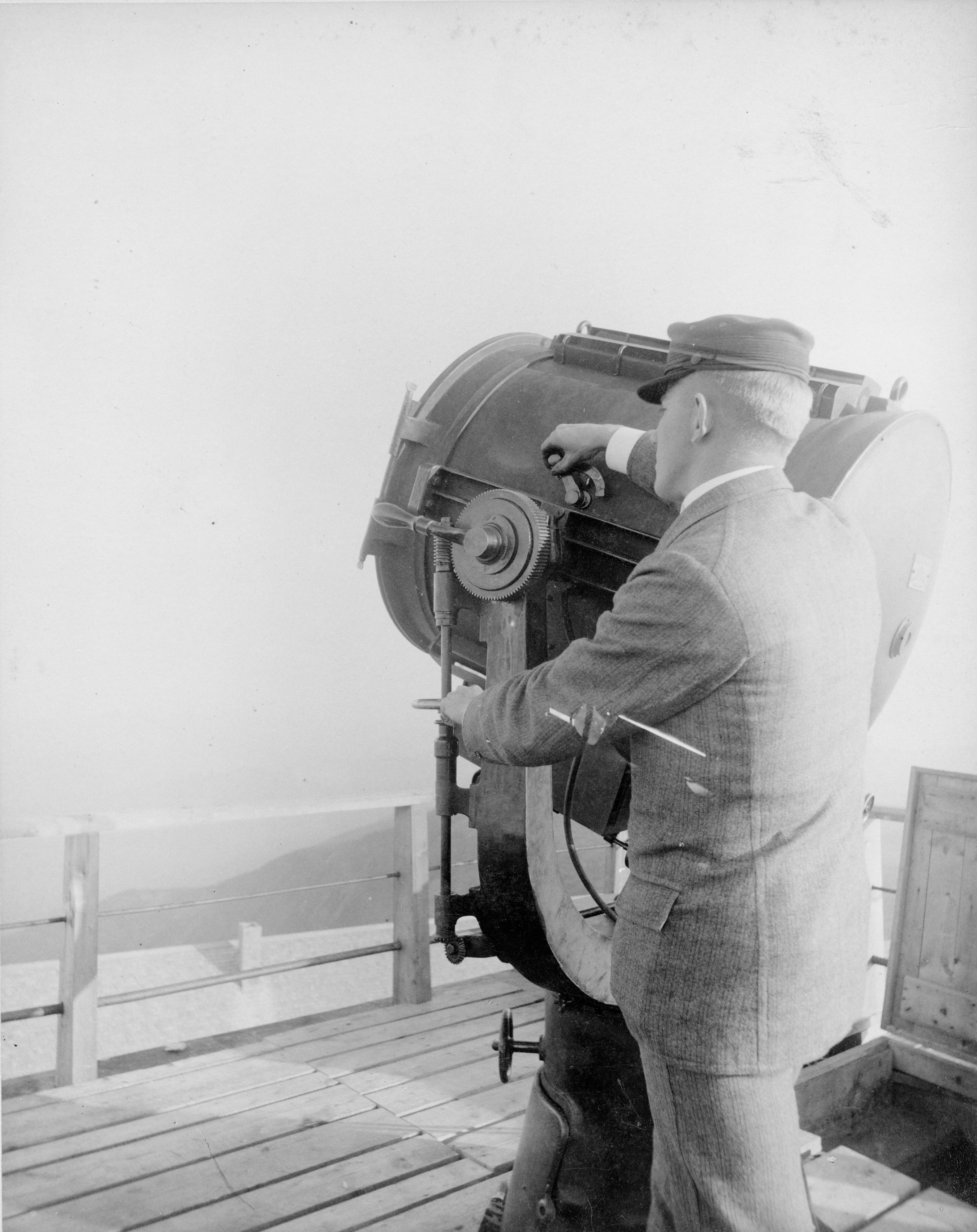
The initial idea for installing a massive steam power electric search light at the top of the Mount Washington Tower appears to have originate from the mind of a salesman, in particular a fellow by the name of Lewis Rogers. He was a selling agent for Thomson-Houston Electric, a maker of generators, or dynamos.
The proposal, accepted in 1882, was that the search light would be funded through hotel and railroad subscribers and paid for with a 25-cent admission. The tag line for the whole operation was jokingly referred to as “moonlight for sale.”
But it was no joke. In fact, the light became a wonder of modern science. According to a visiting reporter, the tower spotlight was so bright, that were the light to be shined on Fabyan's, eight miles away, in the middle of the night, common type could be easily read. The spotlight was so popular that people in surrounding villages near the mountain would light bonfires at night in the hope that the spotlight operators would turn the beam toward them.
Tower operators even considered using the light as a beacon to aide lost hikers, a sort of lighthouse to show trampers the way.
Sadly, the search light didn’t last long, according to Walters. Seeking a great audience for such a wonder, the following season, Rogers moved the light to Manchester where it was installed in a tall building in the center of the city. In Rogers mind, the light could be used as a “cloud projector” to beam news and advertisements into the sky. In fact, Pickering lent him several lenses to experiment with.
But then things get fuzzy. The light moved to Boston, and then there’s some notes here and there about it going on to the Chicago Columbian Exposition in 1893, or even on to Mount Echo in California. Rogers himself moved to Ohio and the great Mount Washington search light became a thing of legend.
Back in New Hampshire, the tower, no longer with an official purpose, became a simple observation platform, but as tourist traffic decreased, maintenance also ground to a halt and the mountain’s infamous weather began to take its toll.
So, in 1902, without much fanfare, the tower was taken down and another important chapter in the mapping of the White Mountains closed.
The tower and early AMC members that first conducted surveys there play a critical role in the mapping of the Whites. As Edmands himself wrote about that first map and book in the typical understated fashion of the day, “Pickering’s little book and map will prove a valuable aid to further work on the topography of the Presidential Range.” He was right.
A very interesting piece of New Hampshire history! I've always cartography incredible.